-
 HYPACK OFFICE: is the survey data processing and final products version of HYPACK MAX. It supports processing and final products, from any survey data collected with MAX (excludes multibeam and LiDAR.
 -
HYPACK OFFICE & HYSWEEP OFFICE HYPACK OFFICE & HYSWEEP OFFICE: The OFFICE COMBO is recommended for planning, editing and generating final products from anytype of survey data collected using the MAX or HYSWEEP modules.
-
 HYPACK SURVEY HYPACK SURVEY: is the data collection-only software, where editing and final products are being handled by other means. It has no editing or final product tools. SURVEY supports survey mission planning, navigation, and data acquisition from various sensors, except multi beam and LiDAR devices.
 -
 HYPACK SURVEY & HYSWEEP: is the recommended combination when outfitting a multibeam survey vessel, ASV or USV. SURVEY & HYSWEEP supports logging any kind of data supported by HYPACK software products (MAX and HYSWEEP). It also supports data processing; however final product generation is not supported with this license.
 -
 HYPACK VIPER: Visualization of environmental sensor data. Choose from over 50 sensor variables and view them in profile, gradient or spreadsheet view.
 -
 HYPACK WATER QUALITY MAPPING: is the software for environmental sensor (water quality and velocity) data collection and processing. The WATER QUALITY MAPPING license includes support for various water quality sensors (up to 32 parameters), acoustic Doppler current profilers (ADCPs) and basic bathymetric mapping.
 -
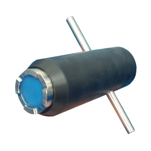 Impact Subsea FMD System Equipment to supply a titanium FMD instrument, ROV probe holder, 0.5-meter interface whip, USB drive with SeaView configuration software and user manual, quick start guide, transit case and FMD license.
 -
Impact Subsea FMD System Equipment rental to supply a titanium FMD instrument, ROV probe holder, 0.5-meter interface whip, USB drive with SeaView configuration software and user manual, quick start guide, transit case and?FMD?license.
-
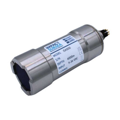 Impact Subsea ISA500 Altimeter Equipment to supply of 6k Depth rated 500kHz Altimeter, 0.5-meter interface whip, USB drive with SeaView configuration software and user manual, quick start guide, and transit case. - 400-600kHz tunable (500kHz Standard) - 0.1 to 120m altitude range - 1mm resolution - 6" conical beamwidth at 500kHz
 -
Impact Subsea ISA500 Altimeter Equipment rental to supply of 6k Depth rated 500kHz Altimeter, 0.5-meter interface whip, USB drive with SeaView configuration software and user manual, quick start guide, and transit case. - 400-600kHz tunable (500kHz Standard) - 0.1 to 120m altitude range - 1mm resolution - 6" conical beamwidth at 500kHz
-
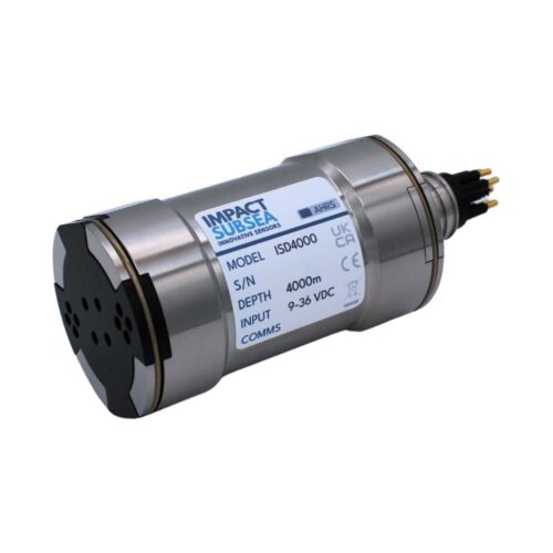 Impact Subsea ISD4000 Depth Sensor Equipment to supply an Underwater depth (pressure) and temperature sensor with titanium housing and integrated AHRS (roll, pitch, heading sensor). Comes with 0.5-meter interface whip, USB drive with SeaView configuration software and user manual, quick start guide, and transit case. Pressure rating: 300dBar
 -
Impact Subsea ISD4000 Depth Sensor Equipment rental to supply an Underwater depth (pressure) and temperature sensor with titanium housing and integrated AHRS (roll, pitch, heading sensor). Comes with 0.5-meter interface whip, USB drive with SeaView configuration software and user manual, quick start guide, and transit case. Pressure rating: 300dBar
Contact us at +1 (706) 522-3022
TOP NEWS!
481 S. Jackson Street
Hartwell, GA 30643
Shop
Your account
Subscribe to our newsletter.
Join our emailing list to receive all up-to-date information from ECHO81
© Copyright 2016 - 2025 | ECHO81 | All Rights Reserved | Powered by ECHO81