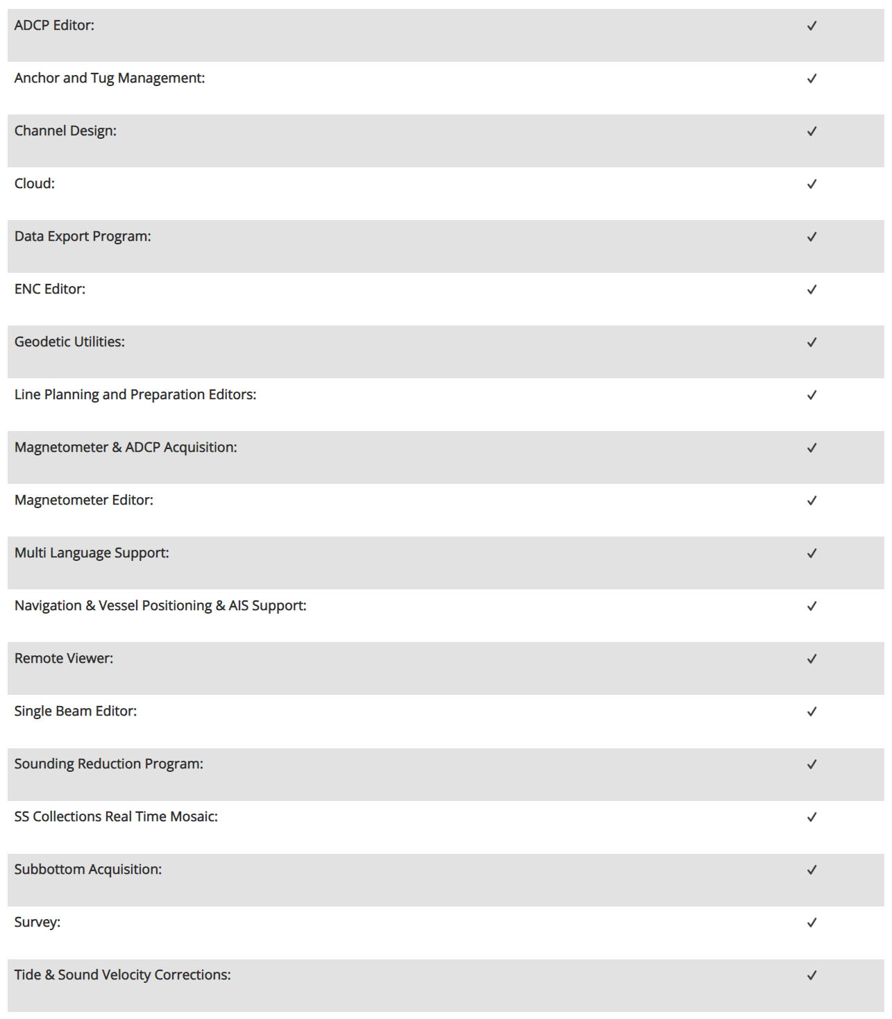
Customize Consent Preferences

We use cookies to help you navigate efficiently and perform certain functions. You will find detailed information about all cookies under each consent category below.

The cookies that are categorized as "Necessary" are stored on your browser as they are essential for enabling the basic functionalities of the site. ... 

Always Active

Necessary cookies are required to enable the basic features of this site, such as providing secure log-in or adjusting your consent preferences. These cookies do not store any personally identifiable data.

No cookies to display.

Functional cookies help perform certain functionalities like sharing the content of the website on social media platforms, collecting feedback, and other third-party features.

No cookies to display.

Analytical cookies are used to understand how visitors interact with the website. These cookies help provide information on metrics such as the number of visitors, bounce rate, traffic source, etc.

No cookies to display.

Performance cookies are used to understand and analyze the key performance indexes of the website which helps in delivering a better user experience for the visitors.

No cookies to display.

Advertisement cookies are used to provide visitors with customized advertisements based on the pages you visited previously and to analyze the effectiveness of the ad campaigns.

No cookies to display.

HYPACK LITE

HYPACK LITE: is the data collection and processing software for all the sensors supported by SURVEY. LITE includes data collection aspects from SURVEY, with the addition of processing tools for the same sensor suite. The data products from LITE can be exported to CAD or GIS.

Product Description

HYPACK LITE: is the data collection and processing software for all the sensors supported by SURVEY. LITE includes data collection aspects from SURVEY, with the addition of processing tools for the same sensor suite. The data products from LITE can be exported to CAD or GIS.

HYPACK® LITE: This is our single beam package designed for users who will perform their final product work in a CAD-GIS package. It contains all of the programs necessary to design your survey and collect the data, then process and export it to DXF/DGN for import into your CADGIS package.

Title

Go to Top