


HYPACK HYSWEEP
HYSWEEP is the module for planning, collection, and processing of multibeam, backscatter, LiDAR, and water column data. HYSWEEP
requires a HYPACK (SURVEY or MAX) license for data collection. The SURVEY or MAX license can be upgraded to support multibeam and LiDAR by adding the HYSWEEP? module.
Product Description
HYSWEEP: is the module for planning, collection, and processing of multibeam, backscatter, LiDAR, and water column data. HYSWEEP requires a HYPACK (SURVEY or MAX) license for data collection. The SURVEY or MAX license can be upgraded to support multibeam and LiDAR by adding the HYSWEEP? module.
This is the module for the collection and processing of multibeam, backscatter, LIDAR, water column data. HYSWEEP® requires a HYPACK license (above). As your agency moves from single beam to multibeam surveying, you can just upgrade your package to multibeam by purchasing a HYSWEEP® license.
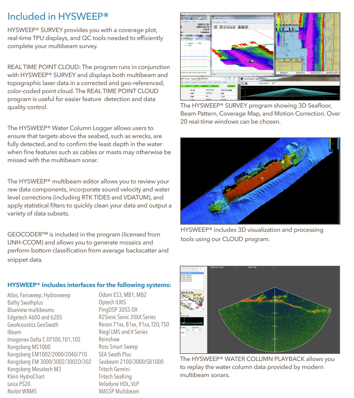
The HYSWEEP® ’ Patch Test allows you to determine the exact mounting angles for your system in hours, not days. HYSWEEP® SURVEY provides you with coverage diagrams, real-time TPU displays, and QC tools needed to efficiently complete your multibeam survey.
REAL TIME POINT CLOUD: The new program runs in conjunction with HYSWEEP® SURVEY and displays both multibeam and topographic laser data in a corrected and geo-referenced, color-coded point cloud. The REAL TIME POINT CLOUD program is useful for easier feature detection and categorization, system calibration and verification, and data quality control.
The HYSWEEP® Water Column Logger allows users to ensure that hard targets, such as wrecks, are fully detected, and to confirm the least depth in the water when fine features such as cables or masts may otherwise be missed.
The HYSWEEP® multibeam editor allows you to review your raw data components, incorporate sound velocity and water level corrections (including RTK TIDES and VDATUM), and apply geometric and statistical filters to quickly clean your data and output a variety of data subsets.
GEOCODER™, licensed from UNH-CCOM, allows you to generate mosaics and perform bottom classification from average backscatter and snippet data.
Factsheet: Hypack Hysweep
CONTACT INFO
Have a question? Can’t find what you’re looking for? We’d love to hear from you!
Connect with us using the information below.
PHONE
+1 706-522-3022
ADDRESS
481 S. Jackson Street
Hartwell, GA 30643
Hartwell, GA 30643
At ECHO81, we believe in the power of collaboration and are proud to work alongside a network of exceptional partners who share our commitment to excellence. We work with EdgeTech, Kongsberg, Applanix, AML Oceanographic, and many more.
We are always looking for new ways to grow and improve. If you have any questions, feedback, or would like to learn more about how ECHO81 can assist you, please don’t hesitate to Contact Us